Tuesday, August 27, 2019

Brown Creek Campground & Lopez Island (WA)

Following our stop at Mount Ranier, we headed to the place Margaret next wanted to camp—Olympic National Park. While stopped for gas in Port Orchard (WA), our nephew, Joshua, contacted me, surprised that we were "already" in Washington and not too far away from where he and his family were anchored on their sailboat. After a lot of back-and-forth discussion, we decided to head north to visit them, but only after a couple nights of restful camping at the remote Brown Creek Campground.

Brown Creek Campground sign. Photo by Margaret.

We arrived at the campground at nearly 9:00 p.m. on 29 Jul 2019 but lucked out and found a nice pull-through campsite. Unlike the campground we last stayed at, Brown Creek was quiet and any campfires elsewhere in the campground didn't affect us. There was a hand pump for potable water, but Margaret wasn't able to get it to pump any water. (There is no longer any water, as the well has since failed.) There were vault toilets but no trash service. It had a lovely little creek and a rather stagnant-looking pond, but the trees offered shade, and it was quiet and smoke-free. With Margaret's senior pass discount, it was only $7.00 per night.

Brown Creek. Photo by Margaret.

We stayed there two nights; and on the morning of 31 July, we were on the road (Interstate 5) north to catch the ferry in Anacortes. Margaret does not like driving in big city traffic (Really, who does?), and the interstate traffic was intense through Tacoma and Seattle. Once we were a bit north of there, it was much more pleasant driving conditions. In Anacortes, we gassed up the Roadtrek and made a grocery stop at Safeway. We caught the next to last ferry of the day to Lopez Island, and over the water, we went. (Pretty exciting for these ferry riding novices!) It was a beautiful 45 minutes or so on the ferry. Once we disembarked, it was just about a mile to Odlin County Park (pronounced ODD-linn) where we were extremely fortunate to get a lovely campsite for two nights.

The Salish Sea shoreline at Odlin County Park. Photo by Margaret.

During our two-night stay at Odlin County Park, Margaret took Peaches for a long walk on a trail. We enjoyed watching in wonder as a doe and her two fawns grazed very near to the Roadtrek both days. It also rained during our second night, which is lovely to watch and listen to through the usually-open jalousie windows next to our beds.

Peaches on one of her "adventure walks" with Margaret at Odlin County Park. Photo by Margaret. 

Our nephew told us that people are allowed to park their vehicles for free up to 72 hours on Tower Drive in Lopez Village, so we planned accordingly—two nights at the county park and three nights in the village. There were public restrooms and showers (which we took advantage of immediately!) in the village park. Shortly after our showers, our nephew and his family arrived! We hadn't seen our deceased sister, Jacqueline's, son, Joshua, for nine years; and I had not met his wife, Breanne (although Margaret had years ago), or their four young sons. Fortuitously, Jacqueline's other son, Caleb, was going to be visiting the same weekend. The first visit we spent catching up and getting to know Breanne and our great-nephews—ages 8, 5, 3, and 15 months. The adults sat and talked while the three older boys kept busy running around, and the baby toddled about. After Josh and his family went back to their boat, Margaret treated us to delicious udon noodle bowls at Satsunai Noodle Bar. Yum!

My delicious dinner: veggie udon noodles. Photo by Virginia.

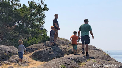
Bright and early the next morning, Caleb arrived on a ferry; and he and Josh took Margaret and me to a laundromat. Showers and clean clothes...what an amazing feeling! Later in the morning, we all went to Shark Reef Sanctuary, including Peaches, for a lovely mile or so walk over exposed tree roots and embedded rocks. The trail ended at some rocky cliffs with a view of San Juan Island and the Strait of Juan de Fuca. The "boys" climbed the rocks and trees, while we women merely walked and talked. Just offshore on some rocks were a number of sea lions sunning, which we all enjoyed watching. We concluded our walk at a shaded picnic table to enjoy some refreshing watermelon. We all had a great time together.

Climbing rocks (L to R): Silas, Malachi (MAL-uh-kye), Caleb, Josiah, & Josh. Photo by Virginia.

The Salish Sea and San Juan Island. Photo by Virginia.

Breanne carrying Micah (MYE-cuh). Photo by Virginia.

Later that afternoon, Joshua picked up Margaret and me and took us in his tiny dinghy to his 45' sailboat, where we were treated to a delicious veggie spaghetti dinner. There wasn't enough wind to sail, so he motored us out in a huge loop from Fisherman Bay north to near Friday Harbor on San Juan Island and back to Lopez Island. 

Lopez Island from the sailboat. Photo by Margaret.

Josh's three older boys are seasoned sailors and are very much at home on their home on the water. The five-year-old is especially fearless and had me quite nervous as I watched him maneuver his way around the boat.

Fearless five-year-old, Malachi. Photo by Virginia.

Following behind in the wake of the huge ferry made for a rockin' and rollin' good time!

The ferry, NV Chinook, leaving Friday Harbor. Photo by Margaret.

Our extremely knowledgeable and capable nephew had a goal to live on the water and worked hard to make it happen. His wife, Breanne, is a very supportive and flexible partner and first mate. Watching her with their four extremely active sons, she exhibited nothing but kindness and patience.

Our nephew, Josh, the captain. Photo by Margaret.

We brought our camp chairs along so we could sit on the foredeck. I didn't trust my balance at all and stayed put. The cool weather, pleasant company, and incredible views were all available to me right there and I was supremely happy! When Josiah, our oldest great-nephew (8 years), asked me to read his favorite book to him, my initial feeling was panic, as I hadn't read to a child since I last read to my daughter about 13 years ago. I had to draw on the many years dormant sense of enthusiastic delivery required to hold a young child's interest in a story. I was relieved it went as well as it did. Josiah, (nephew) Caleb, and I all seemed to have a great time, though. Whew! 

(l to R) Margaret, Caleb, Virginia, and Josh. Photo by Breanne.

That evening the sunset and its reflection on the water was a strikingly vivid orange. Its glowing warm hue contributed greatly to my feeling of serenity when partnered with the gentle movement of the boat over the calm waters.  

San Juan Islands sunset. Photo by Virginia.

Although I absolutely love bodies of water of every kind, I do not have "sea legs," as I have many issues with balance. I also feel a strong avoidance of being in water I can't see through and where there are native "inhabitants." So, getting in and out of the tiny dinghy that delivered us to and from the large sailboat sort of freaked me out, especially since it was nearly dark on our return to land. Josh and Margaret were patient with me; and I didn't fall out, which made the entire evening positively memorable. Yay!

The next morning they took us to Watmough Bay on the southeastern end of Lopez Island. It was an easy walk, and the bay was lovely. The older "boys" again went rock climbing, while we women, Peaches, and the two youngest great-nephews, Silas and Micah, stayed on the ground. After tiring of waiting in the sun, Margaret decided to take Peaches on a different trail back to the parking lot. It was much more challenging than the one we came in on, but they made it back okay to Breanne and me returning on the first trail. The brothers and the two older boys arrived shortly after Margaret and Peaches on the second trail, as well.

Part of the family by Watmough Bay. Photo by Virginia.

We had a lovely picnic lunch in Lopez Village Park, after which Caleb left to catch an afternoon ferry back to the mainland. Hopefully, we will see him before another nine years go by.

Aunties, nephews, niece, and great-nephews. Photo by Breanne.

After a bit of a rest, Josh came to take Margaret for her first kayaking experience, which she absolutely loved! Uh oh, where exactly are we going to put a kayak on the Roadtrek? :>)

 Margaret during her first kayaking experience. Photo by Josh.

Fairly early the next morning, Margaret and I drove away from Lopez Village and got in line for the ferry back to Anacortes. Josh, Breanne, and the boys came and hung out with us until it was time to board. Then we were back on the water contemplating our weekend with family on the laid back and charming Lopez Island and thinking about the next leg of our adventure, which turned out to be another island. Cool!

Sunday, August 25, 2019

La Wis Wis Campground & Mount Rainier (WA)

On the morning of 24 Jul 2019, we left French Prairie Rest Area late enough to avoid the Portland commuting traffic and drove over the Interstate Bridge into Washington State at 12:30 p.m. We stopped for water, ice, and groceries in Vancouver, Washington, before continuing north on Interstate 5. We checked several sources for an open campsite near Mount Rainier; but after exhausting those sources, we decided there wasn't one available where we might be able to see it from the campground. We drove east on U. S. Route 12; and 2-1/2 hours later, after passing Mayfield Lake and Riffe Lake, we arrived at La Wis Wis Campground in Packwood, Washington.

La Wis Wis Campground sign. Photo by Virginia.

The campground is in an old-growth stand of Cedar, Hemlock, and Douglas Fir trees located in the Gifford Pinchot National Forest. It was rather warm (77°F) when we arrived, but we were pleased to find several available campsites in Loop B. We settled on site #10 and set up camp (which essentially means leveling the Roadtrek, putting out two camp chairs and their cushions, putting up the insulating Mylar and Reflectix in the windows, and shifting our gear from the back to the front). We decided to stay for 5 nights, which, with Margaret's senior pass, made it $10.00 per night. The amenities include asphalt roads and pads, potable water, vault toilets, recycling, and garbage. What we didn't have available (again) was any cell phone signal.

La Wis Wis Campground trees. Photo by Virginia.

It was extremely quiet for that first day (Wednesday) and evening. And very dark! Those old-growth trees seemed to filter out any of the last quarter moonlight.

La Wis Wis Campground forest. Photo by Virginia.

This forest was the first primeval-looking one I have visited. There was lichen and moss covering most every tree and huge ferns among the other varieties of ground covers. There were also flies and mosquitoes, enough to be a nuisance. During the five days we were there, I saw only one chipmunk, a couple of small birds, one Stellar's Jay, a number of crows, and quite a few ravens. I expected to see more than that. Where were they? Hmm….

La Wis Wis Campground. Photo by Margaret.

Unfortunately, the breathtaking aspects of the forest weren't just in its appearance; they were also due to the massive amount of campfire smoke trapped by the dense trees because just about everyone but us enjoys campfires. (The fire part isn't the problem; the smoke is.) Smoke is especially a problem for Margaret, who never smoked but still suffers from asthma, COPD, and one less lung lobe due to cancer. One morning at about 3:00, I awoke and could finally smell the woodsy aroma of the trees after a particularly smoky day. How purely fresh it was!

La Wis Wis Campground trees. Photo by Margaret.

The forest took on a decidedly different appearance one morning, and it was spectacularly different! The bright morning light changed the previously dark and slightly menacing look of the forest.

La Wis Wis Campground morning light. Photo by Virginia.

The beautiful glacier melt-water fed Ohanapecosh River runs by the campground, and it offers a serene place to stop and sit. Just look at how lovely a setting nature supplied.

Ohanapecosh River. Photo by Virginia.

Ohanapecosh River. Photo by Margaret.

Ohanapecosh River. Photo by Virginia.

Our last morning at La Wis Wis (29 July) arrived after a quiet and non-smoky evening since most all of the other campers in our loop had already left. After filling our freshwater tank, we packed up to drive anywhere we could actually see Mount Rainier. Margaret went into the Ohanapecosh Visitor Center for a recommendation to do just that. The ranger suggested we go to Tipsoo Lake; so that's where we went. On the way there, we got glimpses of the mountain; but once we arrived, we were finally beyond mere glimpses. Yoo hoo!

Mount Rainier. Photo by Virginia.

Mount Rainier and Tipsoo Lake. Photo by Margaret.

The little walking trail surrounding the lake was crowded with others admiring the stunning views, which are in every direction. Of course, the star is Mount Rainier itself, the volcano of which naturalist John Muir had this to say: "Of all the fire-mountains which, like beacons, once blazed along the Pacific Coast, Mount Rainier is the noblest."

Tipsoo Lake. Photo by Margaret.

Tipsoo Lake is a favorite spot for photographers wanting to capture the mountain and lake with the area's famously colorful and varied wildflowers.

Mount Rainier and Tipsoo Lake. Photo by Virginia.

Summer flowers at Tipsoo Lake. Photo by Margaret.

After walking around the lake, taking in and capturing the extraordinary beauty we had so looked forward to, we drove out of Mount Rainier National Park toward Enumclaw, Washington, on State Route 410. On one turnout, we spotted four tiny waterfalls that were so cute I got out to take photos and a video of them. (They and all of our other Washington photos are in our Flickr Collection linked at the end of every post.) What a delight to be somewhere with so much water that it's nearly everywhere you look.

Margaret had the Olympic Peninsula in mind for our next destination; so that's where we were headed before what turned out to be a very pleasant diversion caused us to change our plans. Family time, island exploration, and some sailing is coming up in our next post.

Saturday, August 24, 2019

Columbia River Gorge (OR)

It's been a month since we visited the Columbia River Gorge, but traveling and camping has been the priority and not a cell signal or public Wi-Fi. So, better late than never….

We left our second time staying overnight at the Peter Skene Ogden State Park on 22 Jul 2019 and headed north on U. S. Route 97. We drove through miles of cotton and alfalfa fields and the pretty little town of Madras, Oregon. We had a view of Mount Jefferson to the west, while rugged volcanic cliffs were to the east; and through a rather thick haze, Mount Hood eventually became visible. I hadn't seen Mount Hood for twenty-two years! Fortunately, the closer we got, the clearer the sky became. We then drove west toward the busy metropolitan area of Portland, Oregon, because it was Margaret's birthday, and she really wanted lunch from Native Foods Café. While there are three Native Foods Cafes in San Diego (our home base), there is only one in the entire Pacific Northwest! That scrumptious lunch was served in the swanky Bridgeport Village Mall in Tigard, Oregon. We parked in the shade to eat our lunches, which meant Peaches could be let out of her crate (happy girl!). Staying for a few hours allowed us to catch up on our iPhones before it was time to go to French Prairie, a nearby rest area to park overnight.

The next morning we drove through intense traffic in Portland to get to one of the most breathtaking areas in the world—the Columbia River Gorge, where we spent the entire day in a state of wonder. (I'd been there several times when I lived in Portland back in the late '90s, but one can never experience this area too often. Margaret had only seen Multnomah Falls once, possibly in 2003.) The first waterfall we encountered on the Historic Columbia River Highway was Shepperd's Dell Falls. (We bypassed the actual first falls, Bridal Veil, on the way in and out because the parking area was prohibitively busy.) Shepperd's Dell Falls are like a winding ribbon through the rough hillside of trees, ferns, and bushes; and the terrain makes the falls difficult to see and to photograph in their entirety, as you can see below.)

Shepperd's Dell Falls. Photo by Virginia.

Continuing west on the Historic Columbia River Highway, the next waterfall is Latourell Falls, which is a plunge-style fall. It is clearly visible from the road and makes for a dramatic photo.

Latourell Falls. Photo by Margaret.

Our next stop was the Vista House at Crown Point. It had been closed when I visited in the late '90s; so it was particularly rewarding to see it open, busy, and thriving. Inside you can learn about its fascinating history, gather information on the area, visit the gift store (where I bought postcards for my daughter), and buy coffee and edibles at the espresso bar. The view of the Columbia River and Gorge from Vista House at Crown Point is absolutely stunning!


Vista House at Crown Point. Photo by Margaret.

[If you have trouble viewing this embedded movie, you may view it directly on YouTube here: https://youtu.be/4LTXkB6lCXk]

Columbia River (west) from Vista House. Photo by Virginia.

Columbia River (east) from Chanticleer Point. Photo by Virginia.

Further west on the Historic Columbia River Highway, we took a left and headed up E. Larch Mountain Road. It is a two-lane winding highway that took us through soaring trees and a dense fog bank. Once we reached the parking area of Larch Mountain (elevation 3,900 ft.), we were rewarded with a bright blue sky and wispy pockets of clouds that rolled right by us. It was quite dramatic. It was also only 56°F at 1:00 in the afternoon(!)—a drop in temperature of 12° from where we had been at the first two waterfalls. We walked only part way on the Sherrard Point Trail because there were just too many stairsteps for us (100!). We returned to the Roadtrek to make our lunches, which we took with us to eat at one of the picnic tables tucked away under the trees. It was so cool that even I was almost cold. Oh, and we were visited by a very curious chipmunk. We never feed wildlife, but it had obviously been fed by humans before and was quite the brave little beggar! Sorry for no photos of it, but Peaches wasn't going to allow it to get close enough for a good close-up photo.

E. Larch Mountain Road and forest. Photo by Virginia.

As we were descending Larch Mountain Road, we noticed it had rained, whereas it had been all blue skies and dry where we had picnicked only a short while previously. Once back to the Historic Columbia River Highway, our next stop was Wahkeena Falls. This two-tiered waterfall cascades over rocks and through greenery right next to the observation point and under a small bridge where it eventually feeds into the Columbia River. (Check out the movie above, which includes a video of Wahkeena Falls.)

Wahkeena Falls. Photo by Virginia.

With Multnomah Falls being our next waterfall destination, I asked Margaret to pull over to the side of the road just beyond Oneonta Tunnel, which is closed and gated to all traffic. After photographing the tunnel, I turned around to see the view directly below. I think you might appreciate just how grand the cliffs and trees of the gorge are, especially in contrast to how tiny our home on wheels looks in scale.

The Roadtrek on the Historic Columbia River Highway. Photo by Virginia.

The Oneonta Tunnel. Photo by Virginia.

Multnomah Falls is just minutes beyond the tunnel, but it is the most notable of all of the falls in the gorge; and during peak season, finding a parking spot would test anyone's patience. After attempting to turn left into the lot next to the falls for many minutes, we decided to delay Multnomah Falls and proceed to Horsetail Falls, which I've determined, after this visit, is my favorite. This waterfall is a superb example of the "horsetail" style, is extremely visible and accessible, and is uncrowded and quiet, particularly compared with the madhouse at Multnomah Falls (which I would prefer to visit in nonpeak times, if that were possible).

Horsetail Falls. Photo by Virginia.

After literally soaking in the grandeur of Horsetail Falls, taking lots of photographs and videos, and walking down into the pool, we were ready to brave the crowds at Multnomah Falls. We continued east on the historic highway just a short distance where we could take Interstate 84 back west to a secondary parking area for the falls. We had no trouble finding a parking space there; and with just a very short walk to and under I-84 and a railroad bridge, we were there at the falls and Multnomah Falls Lodge. As singularly stunning as the waterfall and the lodge are, the huge numbers of people there that day and the food vendor booths (which were not there when I had last visited) had me feeling this natural wonder is too much like an amusement park now. In that respect, I was quite disenchanted. The waterfall itself is as impressive as ever, though, even with the nearby ridge of trees burned in the Eagle Creek Fire in 2017. Knowing about the fire and seeing just how close it came to this and other landmarks put it all into perspective for me. The devastation has changed the landscape for a very long time, and many trails in the area remain closed.

Multnomah Falls. Photo by Margaret.

The total height of Multnomah Falls is 635 feet; and Margaret, using her trusty iPhone camera, was able to capture the top, the drops, Benson Bridge, and the pool so beautifully. We sat in a couple of provided chairs for a while just gawking, although I found myself trying to tune out all of the crowd noise and concentrate on the music of the falls. It is considered to be the best waterfall in Oregon, and it is world-renowned, deservedly so.

We were able to find a single parking spot at a viewpoint in Corbett where I was able to get the image below. (If you click to enlarge it, you can see Vista House on Crown Point.) With just beauty and grandeur in the photo, I imagine it might be difficult to consider how noisy, littered, and crowded it was. In fact, I was disheartened by the condition of the man-made improvements. The beautiful old stone bridges, walks, and viewing areas were littered, dirty, and had weeds growing up through the mortar. Even with plenty of trash receptacles available, there was a great deal of litter, especially at Multnomah Falls. Why go to these beautiful places just to trash them? I will never accept or understand how humans can be so disrespectful to nature.

Columbia River Gorge. Photo by Virginia.

We ended the sightseeing part of our day at 6:30 p.m., and we were extremely tired and hungry. We gassed up the Roadtrek in Troutdale and found a Chinese restaurant conveniently located next door to the gas station. Margaret treated us to dinner to-go; and because after exhaustive searching, we couldn't find a legal place to park overnight anywhere near our location, we decided to go back to French Prairie Rest Area on Interstate 5. It was nearly 10:00 p.m. when we had the Roadtrek ready for us to sleep and could eat our delicious dinners. Ahh. It had been an extremely long and busy day; but even with the minor disappointments, we each appreciated that we were suitably awed and delighted by all of the remarkable and unique splendor of the Columbia River Gorge. The next day we crossed over the Columbia River into Washington State. Stay tuned for those adventures. Thanks for traveling with us!

Saturday, August 10, 2019

Sisters, OR & Cold Springs Campground

We left our overnight parking site mid-morning on 16 Jul 2019 and went south on U.S. Route 97 before taking State Route 126 west. We had only 25 miles to go; so in about an hour, we arrived in the beautiful town of Sisters, Oregon. A friend drove Margaret through Sisters back in 2002. It was so cute that she was hoping to return eventually and linger awhile. So she added it to our West Coast States Adventure itinerary.

My recollection of Sisters is different from my sister's. ;>) I spent my youth to about age 30 drooling over the photos of the gorgeous horses of Patterson Arabians in the Arabian horse magazines of the time. The Patterson Ranch was a famous landmark in Sisters. The photos of the mares in the pastures with the snow-covered Three Sisters volcanoes in the background were stunning and left a lasting impression on me. The horses were sold off in 1989, and the ranch was sold in 2017. (Here is a 2015 video of the ranch: https://youtu.be/C1sCVqnGEoI.) I didn't know exactly where the ranch was located and ended up seeing it only after Margaret had driven by—a minor disappointment, but I saw enough to get an in-person impression of the beautiful place I remembered from magazines so long ago.

Welcome to Sisters sign. Photo by Margaret.

We parked in a shady spot at Creekside Park and wandered around the adorable and immaculate little city park for a few minutes. We walked over the cute little covered pedestrian bridge that spans the Whychus Creek to the RV park on the other side before returning to the Roadtrek. Then it was time to explore the town on foot.

Creekside Park. Photo by Virginia.

It was only 70°F when we arrived, which made Margaret and me very happy. Peaches? Not so much. She likes it pretty warm. After all, she is a tiny and super short-haired Chihuahua. :>) So Margaret vented the Roadtrek, put the Maxx Air Fan on, and we left the little girl with her Furrybaby blanket and crate bed to keep her warm if she wants to cover herself. Meanwhile, we sisters went walking in Sisters!

One of many light posts featuring a banner and gorgeous flowers in Downtown Sisters. Photo by Virginia.

The traffic on Cascade Avenue was intense in the late morning and early afternoon. Two highways (U.S. Route 20 and State Route 126) merge briefly here, and the traffic is very busy! All of the shop fronts, sidewalks, planters, etc. were attractive and clean. It really is an adorable little town.

Cascade Avenue in Downtown Sisters. Photo by Margaret.

Margaret and I both went gaga for this gorgeous sculpture ("The Wild Stallion") in the center of town. We were both horsewomen for many years, and this sculpture made our horsey hearts go all fluttery. It's impressive, isn't it?

 
"The Wild Stallion" sculpture in Sisters. Photo by Margaret.

By the early afternoon, the temperature had increased a couple of degrees to a whopping 72°! (We are just so wimpy about the heat. 😅)  We both prefer it cool (or cold), so we got a little warm while walking in the sun. There were shady overhangs and benches fairly frequently, though, which are just some of the reasons that Sisters is a great town for pedestrians.

Shops on Cascade Avenue in Downtown Sisters. Photo by Virginia.

Just about every store had hanging baskets and/or planters filled with colorful flowers.

A sampling of the flowers in Downtown Sisters. Photos by Virginia.

There is a fairly wide variety of shops in Sisters. Neither Margaret nor I are jewelry ladies, but we really enjoyed our time in a little shop called The Jewel. Not only did they have unique jewelry, but they had an impressive variety of minerals and fossils that grabbed our attention.

Stitchin' Post store on Cascade Avenue in Downtown Sisters. Photo by Margaret.

Richard's Farmstand, Sisters, Oregon. North Sister ("Faith") of the Three Sisters volcanic peaks in the background. Photo by Virginia.

Margaret treated us to some special "goodies" from Sisters Bakery, all of which were super delicious. Once we had walked up and down Cascade Avenue, we went back to the Roadtrek, made our lunches, and gathered up Peaches to enjoy a picnic under the giant pine trees at Creekside Park. After lunch, Margaret gassed up the Roadtrek, and I stopped in a little market for some local produce. Then we were off to nearby Cold Springs Campground, hoping to find an available campsite for a few days.

Cold Springs Campground sign. Photo by Virginia.

After driving through the entire campground, Margaret found only one campsite that was unoccupied or reserved: the last one, campsite #23. It was the camp host site, but the campground was currently without a camp host. Yippee for us! She initially paid for three nights but decided to add an extra night twice for a total of five nights there. We were in the shade, next to a spring, with a decent cell phone signal (outside). Pretty sweet, huh?

A panorama of our campsite in Cold Springs Campground. Photo by Virginia.

I sat outside in the shade by the spring for several hours each day. Books, music, movies, Web browsing, keeping up with social media, etc. kept me occupied in between being mesmerized by my surroundings. It was probably in the low to mid-70s in the shade during the day and down into the low 50s in the evening. Pretty, cool, quiet, convenient, and with a cell phone signal, all for the discounted price of $7 per night. Woo hoo!

The cold spring for which the campground was named. Photo by Virginia.

I went for short walks around the campground, and Margaret took Peaches for their longer "adventure walks." The campground amenities included drinking water (hand pump!), vault toilets, garbage dumpsters, picnic tables, and fire rings. The trees are mostly Ponderosa Pines, but in the lower, wetter areas there are some Aspen trees.

Cold Springs Campground. Photo by Margaret.

We left Cold Springs Campground on the morning of 21 July after five peaceful nights; and on that bright and sunny morning, we finally had an amazingly clear view of the Three Sisters—the mountains (volcanoes) that the town of Sisters was named for. Beautiful, aren't they? 

The Three Sisters volcanic peaks. Photo by Virginia.

Our continuing adventure includes Margaret driving an entire day to get a special birthday meal. Well, not just for the meal; but it was worth going out of our way a bit. Stay tuned, and thanks for coming with us!